The airmen are measuring winds speeds reaching a maximum of 185 miles per hour.
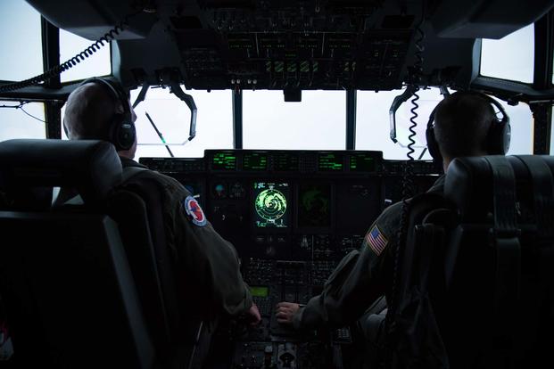
For the last few days, a crew of five airmen with the Air Force Reserve 53rd Weather Reconnaissance Squadron, known commonly as the 'Hurricane Hunters,' have flown six missions on their WC-130J in and out of Hurricane Irma.
The storm is bursting through the Caribbean and gaining on the United States, with expectations of making landfall on Florida as early as Saturday night.
And it's already setting records, said Maj. Jonathan Brady, aerial reconnaissance weather officer, or ARWO, otherwise known as an airborne meteorologist. Brady has been monitoring storm patterns from the ground this hurricane season, tracking data and listening and coordinating with airmen as they penetrate each storm.
"The record [Irma] has set is the strongest hurricane to have ever formed in that part of the Atlantic, and also another record for this strong of a [weather] system being this strong for this many days," Brady said in an interview with Military.com on Thursday.
Related content:
- National Guard Moves Focus as Hurricane Irma Looms
- Navy Evacuates 5K People from Key West, Reroutes Relief Ships
- Military Response in High Gear as Texas Floodwaters Recede
Brady said the storm for more than 48 hours has featured consistent 180-plus mile per hour winds. Normally, a hurricane rapidly intensifies, but will start to eventually weaken sometime within a 24-hour period, he said.
This hurricane has been "a Category 5 for a couple of days now. This storm, it's still game on," he said. "This is going to do far more damage than Andrew," he said, when asked how Irma compares to Hurricane Andrew, a Category 5 hurricane which struck Florida in 1992.
"Andrew was very strong but smaller in size. The other thing with Irma...on it's current track, it's going to go due north" after Florida.
"Irma has potential to do a lot more damage, unfortunately," he said.
Investigating Storms
The teams, based out of Keesler Air Force Base, Mississippi, tracked Hurricane Harvey, which brought devastating rains to Texas and its coastline. The Hunters are up for Irma now, and have flown two missions into Hurricane Katia, which is sustaining 80-mile-per-hour speeds off the coast of Mexico.
They anticipate flying out for Hurricane Jose in the next few days, which will also likely hit the same Caribbean islands Irma is rolling over now. But "it looks like it will curve north very quickly, but it will ultimately become a Bermuda threat in the central Atlantic," Brady said.
Ever wonder what it's like to fly with the Air Force Reserve Hurricane Hunters? Time lapse video of #HurricaneIrma by Maj. Kendall Dunn pic.twitter.com/FqnNsEvIUh
— Hurricane Hunters (@53rdWRS) September 6, 2017
The airmen also operate out of St. Croix in the Caribbean, but for days have been launching from island Curaçao because of Irma's path.
"We've got our hands full with three hurricanes right now," Brady said. Of the 53rd's 10 WC-130Js, only three can fly in different storms at the same time.
Measuring Catastrophe
The Hunters in 2005 added what's called a stepped frequency microwave radiometer, or SFMR. They call it the "smurf." The passive sensor, under the right-wing of the plane, monitors winds and emitted energy from the ocean's surface.
"It's one of the most important pieces of equipment we have. What it's doing is providing hurricane winds speeds back to the National Hurricane Center in Miami. Surface wind speeds are so important because surface winds is what's going to destroy property and endanger lives. So this provides verification...because that's what brings in the storm surge," Brady said.
The data helps the center determine the category to classify the storm, in addition to how far out the winds go and how strong the winds are.
The team also drops a device called a dropsonde into the water, a biodegradable and non-recoverable sensor which measures temperatures, dew-point temperature, pressure and also wind speeds and direction and GPS latitude and longitude location.
Dozens can be dropped throughout a singular six-to-10 hour mission, collecting data from each device as the WC-130 flies through the storm.
"The lower the pressure in a hurricane the stronger it is," Brady said. "If we see a lowering trend that means it's getting stronger."
Brady said the pressures in Irma are lower than expected.
"A standard, normal atmospheric pressure is 1,112 millibars. Irma got down as low as 914 millibars," Brady said. Millibars are metric unit of pressure measurement. Getting below 900 is "amazingly low," he said, and a few storms in the past too have recorded low trends.
"We set a record a few years ago with Hurricane Patricia [in 2015] off the coast of Mexico. At the time that was the strongest hurricane ever measured in the part of the world. It was 897 millibars and had winds as strong as Irma," he said.
Once hurricanes make landfall, the Hunters' mission is done.
Flying a C-130
The WC-130, a modified C-130 Hercules, will fly at speeds that are comparable to the hurricane to more easily fly through the winds before they reach the eye. Normally for any hurricane, the aircraft will stay at 10,000 feet. Storms such as tropical storms or depressions, the plane can drop down between 5,000 and 500 feet to collect data if it needs to.
"We're taking it and flying just like a normal day of business. I've always felt very safe in it," Brady said. The WC-130 will fly cockeyed into a storm, what the airmen call crabbing, which is almost in a jackknife position to circumvent the winds as they fly through.
"The stronger the storm, the more angled we fly to get in there," he said.
This year, the 53rd has added a Go-Pro camera to the window where the someone like Brady, the ARWO, would sit.
The purpose is to have the camera collect images below for new trainees so they "can really see what the different sea states look like," he said, referring to what knot speeds would look like from the aircraft.
The crews would like to add another radar for the belly of the plane, in order to get even more wind speed estimates at new vantage points. Brady said the Air Force is looking into the additional technology.
From Harvey onward
Coming off of Harvey, Brady said this is not the first intense season for the 53rd WRS. In 2005, both NOAA and the Air Force tracked "so many storms, the [World Meteorological Organization] ran out of names," he said. That year included Hurricane Katrina which devastated Louisiana.
"An absolutely horrific year for hurricanes -- our squadron was worked to its limit," said Brady, who's been a weather officer since 2003. He joined the 53rd WRS in 2011 after transitioning from active-duty to the reserves.
For this season, the Air Force's Hunters started flying out for Harvey at the end of August and racked up 13 missions with 104 flight hours (the National Oceanic and Atmospheric Administration, or NOAA, also has its own set of hurricane hunter aircraft).
Harvey at one point "fizzled out, but as it approached the Yucatan Peninsula...the models were hinting once it got past the peninsula and into the Gulf, it would get the chance to regather steam and organize...into a hurricane again," Brady said.
Texas officials have said the Category 4 hurricane storm was the worst climatic disaster in Texas history, with military and civilian relief efforts still underway to work through the massive flood damage and provide food and shelters. The U.S. Army alone deployed 16,000 soldiers into the response; each service branch contributed personnel, aircraft, and even two Navy destroyers to relief efforts.
Now Guard members and Florida officials are on standby as Irma looms.
To be clear, there's no such thing as a Category 6 Hurricane. But Irma "is very impressive meteorologically. I'm kind of shocked and awed by how powerful it is," Brady said.
-- Oriana Pawlyk can be reached at oriana.pawlyk@military.com. Follow her on Twitter at @Oriana0214.

")
")
")

")
.")
.")
")


")
")
")
")
")
")
")
")
 boat maneuvers in front of the USCG Cutter Fredrick Mann (WPC1160) in Women's Bay during ARCTIC EDGE 2026 (AE26) at U.S. Coast Guard Air Station Kodiak in Kodiak, Alaska, Feb. 27, 2026. (U.S. Marine Corps photo by Lance Cpl. Thirteen Bahizi)")