Law enforcement and even U.S. Coast Guard personnel can't always reach lost hikers, injured boaters and downed aircraft -- cue a handful of airmen at the Air Force Rescue Coordination Center.
Crews working in shifts around the clock in the center at Tyndall Air Force Base in Florida help fill the gap when state or local officials don't have the resources to rescue missing persons within the U.S.
It's like combat search and rescue, "but for civilians," said Lt. Col. Evan Gardner, director of operations for the center, who recently sat down with Military.com for an extended interview about the mission.
The center, which falls under the command of 1st Air Force (Air Forces Northern), dispatches resources at the request of a state or federal entity, as well as government agencies in Mexico and Canada.
In 2016 alone, the center helped to save 354 lives on 969 missions -- a new record for the rescue command, Gardner said. Indeed, since activated in 1974, it has saved a total of 16,554 people and boasts the highest saves-to-mission ratio of any command in the service.
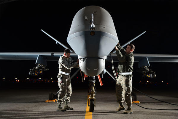
Drone Search-and-Rescue Flights
Some operations require the service's unique surveillance assets, including drones.
In 2015, two missions used unarmed MQ-9 Reapers over California, marking a first for the medium-altitude remotely piloted aircraft nicknamed the "hunter-killer." The flights helped narrow down where the missing adventurers "were not," said Lt. Col. James Woosley, commander of the center.
Officials said one individual was a missing mountain biker and another person was stranded in a forest amid a wildfire, but didn't go into detail on the rescue operations.
Domestic drone surveillance flights don't happen often -- only when all other options have been analyzed and with approval from the head of U.S. Northern Command and, in some cases, even the secretary of defense.
Officials would rather deploy, for example, an HC-130J aircraft from Davis Monthan Air Force Base in Arizona to "go out and do exactly what the MQ-9 can at a lower altitude," Woosley said.
"It has to be very specific niches where it would fit," Woosley said, referring to a drone. Some examples include when weather conditions prevent a low-flyover from a manned aircraft or rugged terrain bars a helicopter from conducting a search and rescue flight.
There are no aircraft for the center's mission at Tyndall. Personnel must work with other commands to receive surveillance information from fleets. For example, the airmen collaborate with pilots and intel analysts at Air Combat Command to access to video feeds from MQ-9 drones.
In the case of the Reapers, "they can stare overhead longer, but it still requires a team of analysts -- 100 hours of analysis for one hour of flight time, and you're normally working against a 72-hour clock," Woosley said.
The center typically gets the mission on day two or three of the search and rescue.
In the two aforementioned missions involving Reapers, both individuals were found dead. In that kind of outcome, "There's no more mission for us," Woosley said. Recovery is done by local authorities, he said.
Locator beacons, cell phones
Personal locator beacons often used by hikers and emergency locator transmitters on aircraft are all monitored by the AFRCC, Woosley said.
Once pressed, the beacons -- a little bigger than an iPhone that users register online and activate -- send a signal to a satellite that will travel through a network of ground stations and eventually to the center's operations center. The device, with GPS-encoded position that can pinpoint a location down to the 100-meter level, has been in use since 2003, according to the center's website.
The center can track cell phones, too.
"It's a goodwill gesture on the cell carrier's side -- they provide some information that's useful for triangulating positions just based on cell phones," Gardner said.
A cell phone is a passive way to find someone and the device must already be on, Woosley explained.
"We're not allowed to turn those on. Cellular forensics, it's not just a ping from a tower, it's a team of folks who have a computer-based algorithm … that can calculate signal strength" over and over within a tower range, he said.
"As we get more and more pings, we get more and more accurate. A lot of times, it saves the [Defense Department] a fortune because we can call a county sheriff … or send [emergency medical services] directly to [the missing person], rather than launching a $3,800 per flight hour asset to fly out there," Woosley said.
The presumption must be, "This person wants to be found in a search and rescue scenario," such as being reported missing by a friend or family member, Woosley said. "We always do the homework ahead of time and validate that, calling the appropriate agencies and getting a legal opinion.
"Funny enough, when we ping them, it's often a text that says, "On behalf of the Air Force Rescue Coordination Center, we see that you may be in distress.'" And the person can just text back, he said.
Mission Uptick
In the last three years, the center is seeing more missions -- from roughly 20 incidents a day to 50, Woosley said. "Due to technology … our efficiencies have gone up, and we … continuously update our processes," he said.
Nine out of ten missions are determined as non-distress, Gardner said. "So the remaining 10 percent are where we are doing extra calls, and sending people out to look."
The center relies heavily on the Civil Air Patrol, the official civilian, non-profit auxiliary of the Air Force. The federally supported organization is an all-volunteer force, which oftentimes knows what may have happened to a downed aircraft before AFRCC or even the Federal Aviation Administration does, Woosley said.
"Every aircraft has a 'squawk' code," Woosley said, or aircraft transponder codes identifying them on radar.
What Civil Air Patrol does is "take all the [unclassified] radars in the United States … and they built a program that they put a math value on" incorporating variables such as take-off time, storms in the area, pilot experience, pressure, altitudes "anything that hits a certain threshold, their computer automatically tells them" where the aircraft could be.
The software is called Icarus, which refers to the Greek mythological character who, with the help of his father Daedalus, constructed two feathered wings glued together with wax. But Icarus flew too high toward the sun, melting his wings and falling from the sky.
"Their ability to find that trail, and then when you pull up the product that they give you … it's very accurate," Woosley said.
Adding cell-phone data or satellite data, anything to corroborate the mission, just enhances these multiple layers that could help find someone, Gardner said.
"Round the clock they work this," Woosley said. "It's technologies like this...that allows us" to get the mission done, he said.
-- Oriana Pawlyk can be reached at oriana.pawlyk@military.com. Follow her on Twitter at @Oriana0214.
Related Video:

")
")
")
")
")
")
")
")
")


")
")
")
.")
")
")

")
")
")
")
")
 crew member wraps bails of illicit narcotics during a drug offload at Port Everglades in Fort Lauderdale, Florida, Feb.13, 2026. (U.S. Coast Guard photo by Petty Officer 3rd Class Moriah Cannion)")